
MotionX GPS HD for Trail Navigation
 When the iPad first launched, I was amazed by the guys over at SoundMan Audio in California. Within a day they had installed an iPad into a Tacoma and from that point on I knew trail navigation would soon change forever. Although my daily driver & current trail truck is an FJ Cruiser, trail navigation is the same regardless of vehicle, so allow me to praise my current favorite app for keeping me from getting lost.
First though, a little history.
When the iPad was released in 2010 there weren’t many apps that took full advantage of the larger screen. In fact, other than a few games, we were stuck with the dreaded 2x version of older iPhone apps. What’s more, there weren’t many iPhone apps that would meet my needs for trail navigation. My simple requirements for any good trail navigation app are:
- Topo maps that can be downloaded for offline use
- Ability to easily import & create GPX files
- Easy to use, taking full advantage of the iPad screen size
The first app I used when I mounted the iPad in our FJ (see January 2011 issue of FJC Magazine), which was the only app that came close to working for trail nav, was EveryTrail. I enjoyed the app so much in fact that when I started working with FunTreks in March 2011, we created 100 eGuides specifically for the system. While EveryTrail is a fine app, it was never meant to be used on an iPad, and importing GPX files took way too many steps. There must be something better. MotionX GPS HD was the answer.
I have actually tried many more apps within the last year that are all very good. In addition to MotionX GPS HD, there’s the National Geographic TOPO Maps, GAIA GPS, and ViewRanger. All of these support my three basic requirements fairly well, but only one is constantly in use when I’m on the trail.
Motion X GPS (MXG) and Gaia made the final cut in my previous comparison of trail navigation apps (April 2012, FJC Magazine). I wanted to focus a little more on Motion X this time since it’s my primary trail nav app.
The biggest feature MXG has over other options is the ease of importing GPX files. This is very important since I’ve been using the FunTreks Data Card for Colorado, Northern Colorado, Moab, and Arizona. I’m constantly adding & removing trail tracks from the iPad, it’s not feasible to store that much data in any system without clutter.
(photo Import many tracks is easy.png)
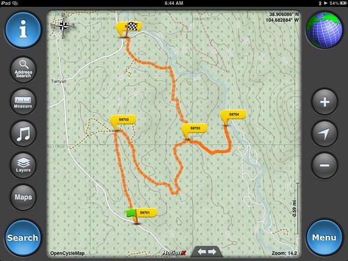
MXG makes adding and deleting tracks as easy as syncing the iPad. Simply plug it in, open iTunes, head to the Apps tab, and manage the files. I usually load all the files for the area I’ll be exploring, but sometimes I’m a little more selective. MotionX GPS HD supports a maximum of 500 waypoints, so that’s the limitation that prevents loading all trails from a given data card. Once they’re on the device, tracks are easy to manage, follow, or modify from within the app.
Downloading maps for offline use is fairly simple as well. What I usually do is find the track(s) for the area I’ll be visiting and tap ‘start follow’. This gets the main MXG map centered on the proper area. From there, tapping into the new download area is quick, and after selecting the map type (MotionX Terrain) the view levels I want, the download begins. Depending on the area you’re downloading and the view levels, this process can take a few minutes or an hour or more. I highly recommend you use WiFi to download your maps.Where MXG really shines though is in ease of use. With large, easy to read buttons and controls, it’s simple for my co-pilot to manipulate the maps when needed. Following a track couldn’t be easier, and there’s even a full-screen mode that shows more map and hides all the controls. Of course I can track my current route with MXG if I’m in an area that’s unfamiliar, and there are many different layers and view options available.
Disclaimer time: We never travel any backcountry routes without appropriate paper maps despite how many electronic devices we carry. iPads & GPS units are great, but they will do you no good when they get broken or run out of batteries. Always carry appropriate paper maps and guidebooks as a backup for the eventual electronic failure.
At this point I can’t imagine using a different app for on-trail navigation. Others have their merits, for sure, but for my specific needs and preferences, Motion X GPS HD is the one to use. Have you used Android or iOS apps for backcountry navigation? What do you prefer? Hit us up on Facebook or the Forums with your thoughts & ideas on backcountry nav.
More Photos!
[flickr set=72157631752693066]


Remember, tell your friends! They can subscribe for FREE using this link!
Find Us On: 
