
AZFJ Monsoon Border Run

 Most would say Arizona is just a hot desert. You’ve been to the Grand Canyon and saw the big hole in the ground, but have you been to southern Arizona and witnessed the grandeur of the wide open ranges around the Patagonia Mountains and the San Rafael Valley? I got that chance when I was made aware of an Arizona FJ event called the AZFJ Monsoon Border Run. They run it every few years. It’s an all day adventure starting in Tuscon and stretching south to the Arizo-na/Mexico border and back up to Sierra Vista for dinner then completing a huge loop back to Tucson.
The rendezvous was at S. Houghton Rd. off the 10 freeway. As I got off the freeway all I could see were a ton of mostly FJs lined up on the wide shoulder. Everyone was milling about taking photos and greeting one another. It was already hot at 10 am in the morning. This was no ordi-nary gathering of “let’s meet and ride” folks. It was officially organized and ran like a major event. James “Jimbolio” Long was our fearless trail leader. He had a table set up to check in all the participants and each received a name badge and list of HAM operators in the lineup. Anoth-er member of the non-club AZFJs was handing out official event t-shirts to those who ordered one. Once everyone was checked in, Jimbolio went over the itinerary and route as he pointed to the large topo map mounted to the side of his Sun Fusion FJ. He was wearing a plastic conquis-tador’s helmet as he tried to channel Spanish explorer Francisco Vasquez de Coronado who ex-plored much of the area we would be driving through.
After the brief history lesson, we all mounted up and began our journey. We stopped and waited along S Sonoita Hwy and collected all the FJs into an impressive convoy. There were a few Jeeps, Tundras and an old Toyota 4Runner. All of which were in good spirits as the CB chatter began. Familiar friends were cracking jokes left and right and Jimbolio dropped tidbits of info of the area as we drove through vast grasslands.
We started to roll through beautiful green hills dotted with Mesquite trees as we made our way to Patagonia, AZ the first stop of the day. On our arrival we were greeted with tree lined streets and historic buildings. It’s a charming little town established in the 1800s with a current population of about 900. It’s named after the nearby Patagonia Mountains and was a supply center for mines and ranches. The local Stage Stop Inn was built in 1969 in part to house the cast and crew of many famous Westerns. Among them are Red River, Rio Lobo, Rio Bravo, Young Guns and Tombstone. We hung around for about 45 minutes wandering through town checking out historic buildings and taking photos while others aired down or topped off their gas.
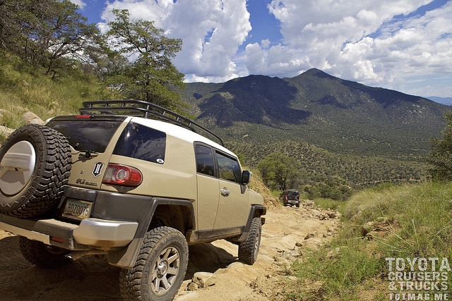
We all saddled up to our rigs and continued on into the hills outside of Patagonia. We were final-ly off road although it was well maintained roads hugging the hillsides. The dust kicked up with each vehicle, but it’s a great feeling when you’re with like minded adventurers out for a romp in the dirt. Next stop, lunch!
Our trail leader led us into a grassy flat lined with Mesquite trees for shade. Puffy white clouds rolled overhead as we all settled in for a bite to eat. Some parked their chairs under trees while others mingled and checked out the various rigs. Kids ran around here and there as kids do and dogs sniffed nature’s scents and panted as the sun bared down. Every one was enjoying lunch among the wilds, but soon we would be coming to our first patch of rough terrain to negotiate.
We were now ascending onto Patagonia Mountain’s shelf roads and would soon come to a dead stop on U X Rd. Chatter on the CB suggested we were stopped to assess the situation at the “In-sane Downhill.” It was hardly insane, but it is a steep down hill and our trail leader and a few others got out to spot us down the hill. The steepest part is made up of very hard sandstone with 1-2 foot boulders thrown in for good measure. As you pointed downhill you could see the can-yon below and the cloud shadowed mountain across the way. Slow and low on the first part then you had to roll over a few boulders and make the left turn, tackle a few more boulders and ruts as you descended off the mountain and finally into the lush green canyon below. All while large cumulus clouds filled with moisture above us. We started back up the top of another mountain and as we made a right turn around the bend we were presented with a spectacular view of the San Rafael valley in the distance. Rain clouds stretched across the skies in all directions, curtains of rain obscured the view as the sun peeked through highlighting portions of the valley floor and the mountain range beyond. A sliver of a rainbow hovered just below the clouds as voices on the CB spoke of the beauty we were experiencing. The views continued on as we traveled along the ridge getting frame after frame of the valley’s landscape and the ever changing weather.
The mountain road was now a winding dirt track weaving in and around cattle ranches. The grass was green and tall and cattle could be spotted under the mesquite trees. There were long stretches of road, the kind where the grass grew in the middle of the track and it was my favorite part of the route. We came upon old dilapidated homes from the past, an old steel windmill and barbed wire fences bordering the lands. We were making our final push for the border and the rain clouds darkened for our approach.
The clouds burst open and it started to dump on us as we parked our rigs for the obligatory photo on the border. It was no different on “the other side.” The green grassy terrain undulated gently into the mountains beyond and it was just as beautiful as the state side. But the border fence looked like we were storming Normandy beach. The border fence was made of recycled, welded railroad tracks and reminded me of the anti-tank “hedgehog” obstacles found on beach heads in WWII. As I snapped several shots of the border lineup photo it rained constantly, but it was re-freshing after a mostly hot day. The sky was grey now and overcast, but the vegetation came to life with a deep green hue. It was time to saddle up again. As the rain continued, the roads be-came slick with mud and it made for a fun departure east to our next stop at Fray Marcos de Niza Historical Monument. A monument built for a Franciscan friar who was the first european to explore the area in the 1500s.
By the time we reached the monument, it was raining heavily so we opted to keep moving while some others split off and headed back north to home and hotels. The rest of us plowed on through the rain and muddy fun to Montezuma Pass and what was to become the greatest sunset and landscape scenery I’d ever have the pleasure to witness.
We were all slowing down before one of many muddy water crossings. Jeremy “The Drone Pi-lot” Lashinke got the camera ready as we each crossed. The sun was hiding behind a blanket of dark grey clouds and brake lights reflected in the mud puddles. It was my turn to cross and I hit it hard with a huge wake splashing high above my FJ. We stopped ahead for a quick break. I opened the door, stepped on the rock sliders and slipped. They were caked in red, Arizona mud. You can’t beat that on a fun day of adventure with friends.
Our day of exploring the wilds of Southern Arizona was coming to a close. We were back on a stretch of dry, dusty road winding up to Montezuma Pass in the Coronado National Memorial. As we approached the parking lot I could see the all too familiar green and white Border Patrol truck and another truck with an unfamiliar apparatus mounted on the back. It was a Mobile Sur-veillance Capability vehicle that uses FLIR (Forward Looking Infrared) ground surveillance sen-sors that could be remotely operated by the agent inside the truck, looking for any suspicious persons. It can capture high-definition video from infrared, visible, and low-light spectrums. Driving around the areas near the border has it’s inherent dangers, but we were reassured when we would see a random BP truck atop a distant hill surveilling the land for any illegal activities.
The Border Run convoy took over the parking lot. Everyone was out and about with camera in tow. The scenery that lay before us to the West was unbelievable. It was a sweeping view of the San Rafael Valley. A great expanse of green grass and trees as far as the eye could see. Imagine the flat valley taking up most of my view. To the right, the valley floor arcs up to several moun-tain peaks. At the center and to the right is a massive wall of rain and it’s backlit by the filtered sunlight. Above it all was a blanket of dense, dark storm clouds in violent torment as it rolled and undulated above the valley. And this was only the beginning of the show. Once the sun set be-hind the mountains northwest of the valley the orange, pink and purple hues exploded behind the curtain of misty rain. It was spectacular. We all stood in awe and agreed that this was the perfect end to a perfect day.
[flickr set=72157660856261007]
![]()
To get your copy of theFall 2015 issue:   FIND US ON: |
|